


la Roda- San Clemete

dagobert5612
User
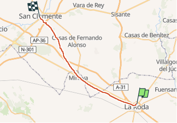

Length
35 km

Max alt
733 m

Uphill gradient
199 m
Km-Effort
38 km

Min alt
705 m

Downhill gradient
193 m
Boucle
No
Creation date :
2023-05-06 03:21:07.15
Updated on :
2023-05-06 13:47:05.794
8h24
Difficulty : Very easy

FREE GPS app for hiking
 SityTrail
IGN / Geographical institutes
SityTrail World
The world is yours!
About
Trail Walking of 35 km to be discovered at Castile-La Mancha, Albacete, La Roda. This trail is proposed by dagobert5612.
Description
camino de levante
Positioning
Country:
Spain
Region :
Castile-La Mancha
Department/Province :
Albacete
Municipality :
La Roda
Location:
Unknown
Start:(Dec)
Start:(UTM)
572789 ; 4340723 (30S) N.
Comments
Trails nearby